Let's start the pictures off with our drive from Las Vegas to Zion. Route 15 parallels the Virgin River for many miles. The drive lead us through the Virgin River Gorge. Here are some pictures. We were going slow due to construction, which made picture taking easier. It was breathtaking!
We were about 20 miles away from our friends. We arrived early the first morning to get on the shuttle buses. There was a line, but we only had to wait for a short time. Before the shuttle I got some pics of the locals.....
Yes, my hair is really short in the back, and the sides are hard to manage. Oh well. It'll grow again.
This is not the best picture, but one of the first. It was early in the day. Phenomenal day. Perfect temperature for a good walk.
Enjoy these pictures of Zion and the Virgin River along the Riverside Walk.
Our friends, Dom and John.

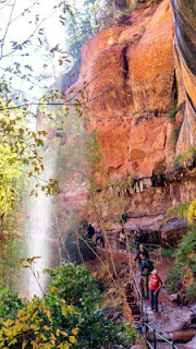
 This is an example of "weeping rocks" I tried to google a good explanation of how this works. The best I could say is water seeps through the rocks somehow causing plant growth along the walls. A great example is the Weeping Wall that was closed due to rock falling in the area.
The Virgin River.
The Virgin River is a tributary of the Colorado River in the U.S. states of Utah, Nevada, and Arizona. The river is about 162 miles (261 km) long.[2] It was designated Utah's first wild and scenic river in 2009, during the centennial celebration of Zion National Park.
The river is named for Thomas Virgin, a member of the first American party to see it, led by Jedediah Smith in 1826. Smith named it "Adams River", after then-president John Quincy Adams, but later explorer and mapmaker John C. Fremont gave it its current name. After the Smith party successfully descended the river on the way to California, Thomas Virgin was badly wounded in an attack by Mohave people during the crossing of the Mojave Desert. Virgin recovered from his wounds but was later killed, along with most of Smith's companions, in an attack by Umpqua people (in present-day Oregon).[5]
Why is Zion Canyon called Zion Canyon?
Information from https://www.myutahparks.com. This seems like a really great site for information.
The first Anglo-European settlers, Mormon pioneers, arrived in the area in the late 1800s. They named the area Zion, which is ancient Hebrew for sanctuary or refuge. The first Mormon resident of Zion Canyon was Isaac Behunin -- his cabin was near today's Zions Lodge site.
The next hike was along the Grotto. On the hike there were more and more spectacular views. I enjoyed the walk instead of taking pictures. The final jaunt of the day was to the Emerald Pools.
Here's a reminder that it is October, and the leaves are changing color, even if it is 80 degrees!
ONE OF MY FAVORITE PICS. I was so excited to see one live in the wild! After we had passed this area on the way back we heard some screaming! lol.
The Emerald Pool. Meh. There were some very tiny waterfalls dripping. Even one you walked under.
Here is a brook on the way back. The pic on the left shows a small teeny waterfall in the middle of the picture. Hmmmm, I'm going to Dom's blog to see if I can steal a pic......
Well, looking at Dom's pictures make me realize my memory of the waterfall was smaller than it really was.
One of the few times I was actually with the group. My short legs keep me lagging behind, plus I kept stopping to take pictures. I'm wearing my favorite shirt that says "Utah Rocks!"
THE NEXT DAY
A few notes about the park we stayed at. It was a 20 minute drive to Zion, not bad. Not a Thousand Trails, but we got a 15% discount for being returning guests. I am standing beside the RV taking the picture on the left. Behind that little trailer is the pool. The building houses a great store. They have something fun planned most nights like hand made ice cream or wine and cheese tasting.
The pic on the left shows how beautiful the mornings are driving to Zion.
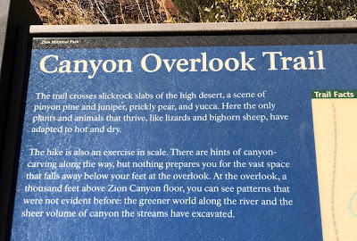
On this day we drove the scenic drive of Hwy 9. If you aren't familiare with this, it is a road that goes up along side and inside a mountain (s) up several thousand feet. Not sure how high. Fantastic scenery! Our destination hike started right where autos exit the tunnel. This hike was rated as moderate. The hikes the day before were rated as easy.
"The vast space that falls away below your feet." Love it!
The two above pictures are from driving to the hike. Click on the picture on the left to get it larger. Look for a small orange dot in the middle. That is the helmet of someone climbing the cliff.

If you've read my post much, you'll know my frustration with this particular program. Moving the pictures or adding text. It takes about 30 minutes to get the pictures in the right place. For some reason this time when I transfer them over they are all mixed up. Right now it isn't letting me write text between the above 4 pictures. Two pictures above show the hill by where we parked. The above picture on the left shows looking down to the end of the tunnel. The pic on right is a deep canyon that I can't see the bottom. Yup, I'm on the edge. Or should I say the path is on the ledge.
 |
| I took this picture standing on the path by the guard rails of the last picture. The red arrows show the path we walked on. |
 |
| And here is the path. |

Let's play I Spy. Above pictures. I spy the road coming out of the tunnel in the picture on the left. I Spy at semi-circle hole that is a "window" in the tunnel. That wall of rock is immense!
Here we are at last. The View. You can see the road we took switchbacking around.
Dom Chang, the photographer and the photos he took.
This long blog is almost over!
The picture on the left shows where we were standing at the end of the Overlook hike. The picture on the right shows a relief map of the park, the black lines are road. The road coming into the canyon on the right is the highway. In the middle of the pic it turns right and that is where we drove the switchbacks to the tunnel to the hike. Where the road goes straight is where you can only ride shuttles into the canyon for the views and hikes. That was where yesterday's hikes were.
I took a pic of this view. Hasn't changed much since the 1930's. I'm sorry I didn't take the picture of the Palute hunter.
When the girls and I went to the museum I found a sign that mentioned an arch in the park. It had this picture with it.
I believe the plaque mentioned that he was a farmer who lived nearby. I found this from https://www.nps.gov/zion/learn/nature/arches.htm
Among the many arches in Zion, two stand out: Crawford Arch and Kolob Arch. Crawford Arch is the most visible, clinging to the base of Bridge Mountain a thousand feet above the canyon floor, and pointed out to casual observers by an interpretive sign located on the front patio of the Human History Museum. For years, rangers in Zion told visitors that this span was a natural bridge (thus the mountain’s name). The Natural Arch and Bridge Society identifies a bridge as a subtype of arch that is primarily water-formed, so by geologic standards it is an arch and in the last years of the twentieth century was referred to as “The arch on Bridge Mountain.” To avoid confusion, the National Park Service eventually named the span Crawford Arch in honor of the Crawford family--among the first Mormon settlers called to the canyon, who toiled and farmed beneath its watchful gaze. Although undoubtedly seen by Zion’s Native Peoples for centuries, the names they gave to this arch in the sky have been lost in the mists of time.
We really couldn't tell from the museum that it was an arch. BUT going back to the campsite the angle was much better and it popped out against the trees.
Here is a current picture of the arch. You can see the museum waaaaay down in the canyon.
Picture also from https://www.nps.gov/zion/learn/nature/arches.htm
Fun photography. Here's Martha taking a picture of me taking a picture.
My last picture of this blog is the Virgin River taken from our RV Park.
Thanks for reading.


Good recap! It’s always interesting to me how others see things and what they choose to capture....makes for a more complete “picture”.
ReplyDeleteThanks, Dom. Starting to work on the Lake Powell and Antelope Canyon blog.
Delete